Hi, we have moved to facebook at https://www.facebook.com/groups/CabaTrails/
Archives here for future reference.
Regards
Ant
Friday, December 23, 2016
Saturday, March 21, 2015
Norries Headland Platform
Just thought I would add a couple of Photos which were taken during the building stage.
We were quite concerned and tried to ensure the platform would cause minimal issues to
the vistas and vegetation. When Tweed Shire Council insisted the structure must be anchored
with footings and be of timber construction the idea of low set rock paving was dismissed.
We were successful in getting a significant increase in seating capacity and the concept of angling
seats to different quadrants of the horizon was accepted. The last photo illustrates that the native grasses have returned and are flourishing.
Sunday, September 14, 2014
Wednesday, September 10, 2014
Round Mountain
 |
Replantings on the north facing slope between the two peaks |
 |
Lake view from the smaller hill |
 |
Views to the west of the high peak |
 |
Bogangar from the high peak |
 |
Lake view from above the saddle |
 |
The sad state of the Trig Marker |
Monday, August 25, 2014
Lake boat ramp to Bush Chapel circuit
GRADE: 2
APPROX LENGTH: 2KM; ABOUT ONE HOUR TO
WALK
ACCESS: Cudgen Nature Reserve Tamarind Ave Bogangar. Parking available at the boat ramp on Cudgen Lake. There are gas barbecues and picnic tables in this area.
DESCRIPTION: A fairly easy walk through
Melaleuca Forest. There are obstacles on the track including many fallen trees
that need to be climbed over. There are no sign posts, however the track is easy
to follow.
- The track commences east of the boat ramp. Stage 1 is a flat, sandy track following the edge of the lake, behind Cabarita Lake Apartments. A small inlet needs to be traversed at this point. This can become boggy following rain. Continue along the lake’s edge climbing over fallen timber.
- The trail will connect with an old Fire Trail after approx 1.15km. Turn left onto this trail and you will arrive at a cleared beach on the edge of the lake. There are superb views of both the Lake and Mt Warning. A great spot for a swim on a hot day or bird watching.
- Retrace your steps back along the Fire Trail (heading East) passing the track you arrived on. Approx 200m along the Fire Trail you will see the Bush Chapel on your right. This originally belonged to Wollumbin Scout Camp and provides a beautiful spot for a picnic.
- The track now becomes harder to follow; head south from the Bush Chapel and you will see markers in the trees and logs marking the track on the ground. Approx 100m from the Chapel you turn right at a burnt tree stump; a further 100m you will see a turn on your right which will lead you back to the original track or continue straight along coming out again at Cabarita Lake Apartments.


Monday, August 19, 2013
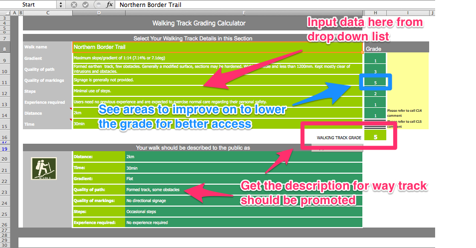
Australian Walking Track Grading System
Mike has shared with me a great resource on track grading.
Here is a small excerpt and a link to the original page.
It has an excel spreadsheet that grades trails and tells you how to promote them.
Example photo below.
Here is a small excerpt and a link to the original page.
It has an excel spreadsheet that grades trails and tells you how to promote them.
Example photo below.
Background to the Australian Walking Track Grading System
The Australian Walking Track Grading System is a technique for uniformly grading walking tracks and communicating that grade to the walking public.
The aim of the Australian Walking Track Grading System is to encourage people who are not regular or confident bushwalkers to get out there and give it a go. It is specifically designed to reassure entry level walkers, particularly the disabled or people walking with children, that a particular track is suitable for their skill level.
Under the new system, walking trails are graded on a difficulty scale from grades one to five.
- Grade One is suitable for the disabled with assistance
- Grade Two is suitable for families with young children
- Grade Three is recommended for people with some bushwalking experience
- Grade Four is recommended for experienced bushwalkers, and
- Grade Five is recommended for very experienced bushwalkers
More info at Australian Walking Track Grading System
Friday, August 2, 2013
Whale Watching Platform Design
We have an opportunity to put our final design concept directly to the TSC Construction Planning team at a site meeting. Interested parties are welcome.
Appointment on Norries Headland
It was resolved at our last meeting to prepare a written brief as an adjunct to Dan Plummer's Concept plan.
The NSW Govt grant matched by TSC work and project management means about two thirds of the plan may be affordable.
Our brief is couched in generic terms so that management of labour coordination, materials handling and protection of the environment is left to those best able ensure the best outcome.
1 AMENITY Build a low level terrace / deck of minimal visual impact. No hand rails.
2 SAFETY Minimize trip hazards and height of deck. Visitors will include small children and elderly.
3 SUSTAINABLE Balance of amenity, cost, durability,
future maintenance.
4 FUNCTION Anticipate the movement of people at this lookout. eg lead additional visitors around (behind) those already seated. Best views are to the east and south so try to pitch seating to different quadrants of this panorama. Provide comfortable seats. Anticipate that some visitors will want to venture further than the platform.
Interpretive signage may inform visitors of Whale Migration also of Major Landmarks-Cape Byron, Hastings Point, Woolumbin - Mt Warning, Kingscliff
5 RESPECT and ensure the beauty of this point,its natural wild exposed ruggedness is not spoilt.
Subscribe to:
Posts (Atom)